![]()

ANNEX E.
MINIMUM QUALIFICATIONS NECESSARY OR OBTAINING CERTIFICATES AS PILOTS AND NAVIGATORS.
SECTION I.
CERTIFICATES FOR PILOTS OF FLYING MACHINES.
A. Private piloťs flying certificate
(not valid for purposes of public transport).
1. Practical Tests:
In each practical test the candidate must be alone in the flying machine.
a) Test for Altitude and Gliding Flight. A flight without landing during which the pilot shall remain for at least an hour at a minimum altitude of 2.000 metres above the point of departure. The descent shall finish with a glide, the engines cut off at 1.500 metres above the landing ground. The landing shall be made without restarting the engine and within 150 metres or less of a point fixed beforehand by the official examiners of the test.
b. Tests of Skill. A flight without landing around two posts (or buoys) situated 500 metres apart making a series of five figure-of-eight turns, each turn reaching one of the two posts (or buoys). This flight shall be made at an altitude of not more than 200 metres above the ground (or water) without touching the ground (or water). The landing shall be effected by:
i) Finally shutting off the engine or engines at latest when the aircraft touches the ground (or water).
ii) Finally stopping the flying machine within a distance of 50 metres from a point fixed by the candidate before starting.
2. Special Requirements:
Knowledge of rules as to Lights and Signals, and Rules of the Air. Rules for Air Traffic on and in the Vicinity of Aerodromes. A practical knowledge of international air legislation.
B. Piloťs flying certificate for flying machines used far purposes of public transport.
1. Practical Tests:
In each practical test the candidate must be alone in the flying machine.
a) The tests for altitude and gliding flight and for skill are the same as those required for a private piloťs flying certificate. Candidates already in possession of the latter certificate are not required to pass these tests again.
b) Test of endurance consisting of a cross-country or over-sea flight of at least 300 kilometres, after which the final landing shall be made at the point of departure. This flight shall be made in the same flying machine within eight hours. It shall include two obligatory landings (during which the machine must come to rest), which shall not be at the point of departure, but which shall be fixed by the judges.
At the time of departure the candidate shall be informed of his course and furnished with the appropriate map. The judges will decide whether the course has been correctly followed.
c) Night Flight. A thirty minutes flight made between two hours after sunset and two hours before sunrise, at a height of at least 500 metres.
2. Technical Examination:
After satisfactory practical tests have been passed, candidates will, when summoned, submit themselves to examination on -
a) Flying Machines:
Theoretical knowledge of the resistance of the air as concerns its effects on wings and tail planes, rudders, elevators, and propellers; functions of the different parts of the machine and of their controls.
Assembling of flying machines and their different parts.
Practical tests on rigging.
b) Engines:
General knowledge of internal combustion engines, including functions of the various parts; a general knowledge of the construction, assembling, adjustment, and characteristics of aero-engines.
Causes of the faulty running of engines and of breakdown.
Practical tests in running repairs.
c) Special Requirements:
Knowledge of Rules as to Lights and Signals and Rules of the Air, and Rules for Air Traffic on and in the Vicinity of Aerodromes. Practical knowledge of the special conditions of air traffic and of international air legislation.
Map reading, orientation, location of position, elementary meteorology.
REMARKS.
The practical tests shall be carried out within a maximum period of one month. They may be carried out in any order, and each may be attempted twice. They shall be witnessed by properly accredited examiners, who will forward the official reports to the proper authorities.
The official reports will give the different incidents; especially those of landings. The candidates shall furnish before each test proper identity forms.
A barograph shall be carried on all practical tests, and the graph, signed by the examiners, shall be attached to their report.
Pilots who hold the military piloťs certificate shall be entitled to the private piloťs flying certificate; but, in order to obtain the piloťs flying certificate for purposes of Public Transport it will be necessary to pass the technical conditions for navigation as required by B (2) (c).
SECTION II.
CERTIFICATES FOR PILOTS OF BALLOONS.
1. Practical Tests:
The candidate must have completed the following certified ascents -
1. By day: 3 ascents under instruction. 1 ascent in control of under supervision.
1 ascent alone in the balloon.
2. By night: 1 ascent alone in the balloon. Each ascent shall be of at least two hours duration.
2. Theoretical Tests:
Elementary aerostatics and meteorology.
3. Specially Requirements:
General knowledge of a balloon and its accessories; inflation; rigging; management of an ascent; instruments; precautions against cold and high altitudes.
Knowledge of Rules as to Lights and Signals and Rules of the Air; Rules for Air Traffic on and in the Vicinity of Aerodromes. Practical knowledge of international air legislation. Map reading and orientation.
SECTION III.
CERTIFICATES FOR AIRSHIP OFFICER PILOTS.
Every airship officer pilot shall have qualified as pilot of a free balloon.
There shall be three classes of airships officer pilots.
The holder of a first-class certificate is qualified to command any airship.
The holder of a second-class certificate is qualified to command airships under 20.000 cubic metres capacity.
The holder of a third-class certificate is qualified to command airships under 6.000 cubic metres capacity.
All military and naval airship officer pilots are entitled to a third-class certificate.
All military and naval airship officer pilots who have commanded airships over 6.000 cubic metres capacity are entitled to a first-class certificate.
QUALIFICATIONS FOR THIRD-CLASS CERTIFICATE.
Practical Tests:
a) Twenty certified flights (three of which shall be by night) in an airship, each flight being of at least one hours duration. In at least four of these flights the candidate must, have handled the airship himself, under the supervision of the commanding officer of the airship, including ascent and landing.
b) One cross-country flight on a predetermined course of at least 100 kilometres, terminating with a night landing, and made with a duly authorised inspector on board.
Theoretical Examination:
Aerostatics and meteorology. (Density of gases, laws of Mariotte and of Gay-Lussac; barometric pressure, Archimedes principle; confinement of gases; interpretation and use of meteorological information and of weather charts.)
Physical and chemical properties of light gases, and of materials used in the construction of airships.
General theory of airships.
Dynamic properties of moving bodies in air.
General Knowledge:
Elementary knowledge of internal combustion engines.
Elementary navigation; use of the compass; location of position.
Inflation; stowage; rigging; handling; controls and instruments.
QUALIFICATIONS FOR SECOND-CLASS CERTIFICATE.
Practical Tests:
To be eligible for a second-class certificate a candidate must be holder of a third-class certificate and have at least four months service as a third class officer on an airship; and also have completed at least ten flights as third-class officer on an airship of capacity above 6.000 cubic metres, in which he has handled the airship himself including ascent and landing, under the supervision of the commanding officer of the airship.
Theoretical Examination:
Advanced knowledge of the subjects required for the third-class certificate.
QUALIFICATION FOR FIRST-CLASS CERTIFICATE.
Practical Tests:
To be eligible for a first-class certificate a candidate must be holder of a second-class certificate, have at least two months active service as a second-class officer on an airship, and also have completed at least five flight as second-class officer of an airship of capacity above 20.000 cubic metres, in which he has handled the airship himself, including ascent and landing, under the supervision of the commanding officer of the airship. Each flight must be at least of one hours duration with a minimum of fifteen hours for the five flights.
Theoretical Examination:
As required for a second-class certificate.
SECTION IV.
CERTIFICATE FOR NAVIGATORS.
Aircraft used for public transport carrying more than ten passengers and having to make a continuous flight between two points more than 500 kilometres apart overland, or a night flight, or a flight between two points more than 200 kilometres apart over sea, must have on board a navigator who had been granted a certificate as such after passing a theoretical and practical examination in the following
1. Practical Astronomy:
True and apparent movements of the celestial bodies. Different aspects of the celestial sphere.
Hour angles, mean, true, and astronomical time.
Shape and dimensions of the earth. Star globes and maps.
Method of determining latitude, longitude, time, and azimuth.
2. Navigation:
Maps and charts-how to read them. Compass; magnetic meridian; variation, deviation.
Courses, bearings, and their corrections. Compensation of compasses (technical and practical).
Calculations of azimuth.
Flight by dead reckoning, measure of the relative speed, drift, traverse table. Chronometer, chronometer rate, comparisons.
Sextants, adjustments. Nautical almanac.
Determination of positions by means of bearing and altitude of stars.
Knowledge of great circle navigation. Aeronautical navigational instruments.
3. General Knowledge:
International rules for air and maritime navigation.
International air legislation.
Practical knowledge of meteorology and of weather charts.
SECTION V.
MEDICAL CERTIFICATES.
International Medical Requirements for Air Navigation.
1. Every candidate before obtaining a licence as a pilot, navigator or engineer of aircraft engaged in public transport will present himself for examination by specially qualified medical men (flight surgeons), appointed by or acting under the authority of the contracting State.
2. Medical supervision, both for the selection and the maintenance of efficiency, shall be based upon the following requirements of mental and physical fitness:
a) Good family and personal history, with particular reference to nervous stability. Absence of any mental, moral or physical defect which will interfere with flying efficiency.
b) The minimum age for pilots and navigators engaged in public transport shall be nineteen (19) years.
c) General Surgical Examination. The aeronaut must neither suffer from any wound, injury or operation nor possess any abnormality, congenital or otherwise, which will interfere with the efficient and safe handling of aircraft.
d) General Medical Examination. The aeronaut must not suffer from any disease or disability which renders him liable suddenly to become incompetent in the management of aircraft. He must possess heart, lungs, kidneys and nervous system capable of withstanding the effects of altitude and also the effects of prolonged flight.
e) Eye Examination. The aeronaut must possess a degree of visual acuity compatible with the efficient performance of his duties. No pilot or navigator shall have more than two (2) dioptres of latent hypermetropia; muscle balance must be good and commensurate with the refraction. He must have a good field of vision in each eye and must possess normal colour perception.
f) Ear Examination. The middle ear must be healthy. The aeronaut must possess a degree of auditory acuity compatible with the efficient performance of his duties.
g) The vestibular mechanism must be intact and neither unduly hypersensitive or hyposensitive.
h) Nose and Throat Examination. The aeronaut must possess free nasal air entry on either side and not suffer from serious acute or chronic affections of the upper respiratory tract.
3. Each contracting State shall for the present fix its own methods of examination until the detail of tests and the minimal standard of requirements have been finally settled by the authorised medical representatives of the International Commission for Air Navigation.
The successful candidate will receive a medical certificate of acceptance, which must be produced before the licence can be issued. 5. In order to insure the maintenance of efficiency, every aeronaut shall be re-examined periodically, at least every six months, and the findings shall be attached to his original record. In case of illness or accident also, an aeronaut shall be re-examined and pr announced fit before resuming air duties. The date and result of each re-examination shall be recorded on the aeronauťs flying certificate.
6. No aeronaut who, before the date of the present Convention, has given proof of his dying ability, shall, so long as he retains such ability, be necessarily disqualified because he fails to fulfil all of the above requirements.
7. Each contracting State may raise the conditions set forth above, as it deems fit, but these minimal requirements shall be maintained internationally.
ANNEX F.
INTERNATIONAL AERONAUTICAL MAPS AND GROUND MARKINGS.
International maps shall be made and ground marks established in accordance with the following general principles:
SECTION I.
MAPS.
1. Two types of aeronautical maps shall be used. They are hereafter mentioned as general maps and local maps.
2. The index scheme for the aeronautical maps, both general and local, shall be based on the index scheme adopted for the "International 1: 1,000.000 scale map" by the official International Congress convened for the purpose in London in 1909 and in Paris in 1913.
Note. - Extract from the resolutions adopted by the Conferences at London and Paris.
The sheets of the international 1: 1,000.000 scale map shall include 6 degrees of longitude and 4 degrees of latitude. The limiting meridians of the sheets shall be at successive intervals, reckoning from the Greenwich, of 6 degrees; and the limiting parallels, reckoning from the Equator, shall be at successive intervals of 4 degrees.
The longitudinal sectors, from longitude 180 E. or W. of Greenwich, are given numbers from 1 to 60, increasing in an easterly direction.
The 22 zones, of 4 degrees in depth, extending from the Equator on each side to 880 latitude, are given letters from A to V.
The polar areas extending for 2 degrees, are lettered Z.
In the northern hemisphere, each sheet shall bear a descriptive symbol composed of the letter N-followed by the zone letter and sector number corresponding it its position, thus: N. K. - 12.
In the southern hemisphere, the letter S shall replace the letter N. Example: S. L. 28.
3. The metre shall be used as the standard of measurement for lengths, distances, heights and depths, reserving for each nation the right to add figures expressing these quantities in its own units.
4. The colours, symbols and arrangements for production adopted for the International 1: 1,000.000 scale map shall be used as far as practicable on the aeronautical maps.
5. The general maps shall be drawn on Mercator's projection and shall be to a scale of one degree of longitude equals three centimetres. The general maps shall have marked on them in fine lines the meridians and parallels of each degree and the meridians and parallels limiting the unit sections of the 1: 1,000.000 map shall be accentuated. The same designation of unit sections shall be used as for the 1: 1,000.000 map.
6. Each general (Mercator) map shall bear the French heading Carte Générale Aéronautique Internationale (see the conventional sign plate figure 1), and under it a translation of this heading in the language of the country publishing the map. It shall also bear an appropriate geographical name.
Each sheet shall show at least the following: principal physical features and geographical names, wireless stations, marine light houses (height and range at sea level, colour and character of the light); national frontiers, prohibited areas, principal air routes, lines of equal magnetic variation, South Polar distance, latitude, old and new notation of longitude (see paragraph 7), with an outer margin containing letters and numbers referring to the index of the 1: 1,000.000 map, legend of symbols in English or French and in the language of the country publishing the maps, publishers name and date of publication and of successive editions.
7. The local maps shall be drawn to a scale of 1: 200.000.
Note. - For local aeronautical maps of sparsely inhabited countries, the scale of 1: 500.000 or 1: 1,000.000, as appropriate, may be used.
In addition to the customary latitude and longitude notations, the local aeronautical map shall bear numbers enclosed in rectangles, corresponding to a new system of co-ordinate reckoning based on the antimeridian of Greenwich and the South Pole. The new grid reckoning, with regard to latitude, shall commence with the South Pole as zero and increase northward by degrees and minutes to 1800 at the North Pole, and with regard to longitude shall commence with the antimeridian of Greenwich as zero and run eastward by degrees and minutes to 360.
8. Each unit sheet of the local aeronautical maps shall bear the French heading Carte Normale Aéronautique Internationale (see the conventional sign plate figure 2) and under it a translation of this heading in the language of the country publishing the map. It shall comprise one degree of latitude and one degree of longitude and shall be designated by a locality name and by the new co-ordinates (described in paragraph 7) of the south-west corner of the sheet, the unit digits being accentuated. In these designating co-ordinates, the figures referring to the South Polar distance shall invariably be written first.
Examples: The sheets whose southern boundary is 49 N. (i. e. 139 South Polar distance) and western boundary 2 E. (i. e. 182 from the antimeridian of Greenwich) will be numbered 139-182.
Or the sheet whose southern boundary is 36 S. (i. e. 540 South Polar distance) and western boundary 70 W. (i. e. 173 from the antimeridian of Greenwich) will be numbered 54-173.
9. The local aeronautical unit sheets shall show, as far as the data is known, the following
a) Within the limiting Meridians and Parallels. - Twenty minute projection grid; roads divided into two classes according to their relative visibility from the air; railways of all kinds; cities and towns in outline and the plan of the principal public roads crossing them (villages similarly if practicable, otherwise their positions indicated); principal features of the surface water system; woodlands and other areas unsuitable for landing, aerodromes, hangars for airships, plants for balloons inflation, permanent landing places on ground and water, aeronautical ground marks; beacons and fixed navigational lights; marine lighthouses height, range at sea level, colour and character of the light); wireless stations, meteorological stations, overhead electric power lines; remarkable objects; national frontiers; the frontier crossings for customs purposes prescribed by Annex H (art. 2); prohibited areas; principal air routes; names of important bodies of water; towns, and important villages; the topographical relief by shading and figures indicating heights, the most important of which to be surrounded by an oval ring as 
b) Outside the limiting Meridians and Parallels. A title, consisting of the name designating the locality and the index numbers of the sheet; a border scale graduated to minutes; the names of the neighbouring sheets; latitude, South Polar distance, old and new notation of longitude (see paragraph 7); scale of kilometres; legend of symbols in English or French and in the language of the country publishing the map; magnetic variation diagram; key map showing abridged numbers of the sheet concerned and the eight surrounding sheets; frontiers and the names of the countries, parts of which are embraced by the key map; publishers name and date of publication.
10. The forms of the general and local maps, titles, marginal notations, diagrams and legends, shall be as shown by the accompanying illustrations.
11. The general and local aeronautical maps and guide books of the areas traversed by the most important routes which may be established by international agreement shall be prepared first.
Note. - On account of the inadequacy of the usual methods of topographic mapping for making aeronautical maps, it is strongly recommended that steps be taken to survey from the air the areas along the most important international routes: Such surveys would furnish indispensable information regarding the features necessary to be shown on the maps the aviator is to use.
II.
UNIVERSAL SYSTEM OF GROUND MARKS.
1. All ground marks shall conform with the scheme of numbering adopted for the unit sheets of the local international aeronautical maps.
For this purpose each mark shall skew (see the diagrams)
a) The abridged number which designates the sheet within which it lies;
b) An open rectangle, whose short sides shall be oriented north-south; the frames shall be open towards the opposite half of the unit sheet;
c) A dot indicating the approximate position of the mark on the north or south half of the corresponding unit sheet;
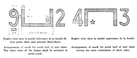
The numbers shall be placed close to the frame at the top, bottom or sides, but not inside.
Where marks are placed so close to each other as to admit of possible confusion, the
round dot may be replaced by a square, triangular or star-shaped dot.
It is recommended that the minimum dimensions of the marks be those indicated in the sketches.
2. Special attention shall be given to the distribution of marks along chosen international routes.
Note. - Steps to establish suitable marks for landing at night shall be eventually taken. In accordance with the decision of the International Commission for Air Navigation.